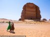
 Google, bastion of cool-tech, has gone Throwback Thursday in a major way – resorting to camels to capture its latest addition to Google Maps. Thanks to their “camel-cam”, you can now explore Abu Dhabi’s Liwa Oasis exactly as the Bedouin have done for centuries, without leaving home.
The Liwa Oasis is best known for its date plantations and was historically used as a trade center by early settlers. Ringed by sand dunes ranging from 82 to 131 feet high, it’s now an off-track tourist attraction.
The surrounding Liwa Desert holds evidence of occupation dating back to the late Stone Age; it’s of the oldest sites in the United Arab Emirates (UAE).
Original article by Laurie Balbo
Continue reading at Green Prophet:
Visit site:
Google Street View uses camels to map UAE’s Liwa Desert
Comments


Comments